NASA EPSCoR funding enables UD’s new remote sensing big data science center
The environment is changing, particularly along our coasts where sea levels are rising.
Knowing how to mitigate these changes requires a deeper understanding of how the coastal ocean responds to global environmental changes and regional processes. This includes the ocean and the land, but also the in-between spaces, such as marshes and wetlands.
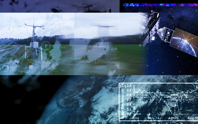
As the most highly instrumented state in the United States for collecting weather, climate and ocean remote sensing data, Delaware is an ideal place to study this problem.
Armed with $749,807 in new funding from the NASA EPSCoR (Established Program to Stimulate Competitive Research) program, researchers at the University of Delaware are developing a remote sensing big data center in Delaware for cutting-edge coastal and environmental change research. The project includes match funding from UD, bringing total funding for the three-year project to $1.12 million.
The work builds on UD strengths in data science, remote sensing and disaster research and will complement its role as a NASA-funded Delaware Space Grant institution, providing training for a new workforce of STEM scientists at the undergraduate, graduate and postdoctoral levels. Researchers involved in the project plan to convert technical data into useful visual information that can help improve understanding for the public and decision-makers involved in setting policy around critical environmental issues.
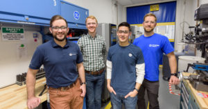
Xiao-Hai Yan, associate director of Delaware Space Grant and director of UD’s Center for Remote Sensing, and Cathy Wu, who directs UD’s Data Science Institute, serve as the science principal investigators on the project. Interdisciplinary co-investigators include Delaware State Climatologist Dan Leathers, Tracy DeLiberty and Pinki Mondal, all professors in geography and spatial sciences; Rodrigo Vargas, associate professor of plant and soil sciences; and A.R. Siders, assistant professor and a core faculty member in UD’s Disaster Research Center.
Making sense of lots of data
Remote sensing is the use of satellites to collect information about and take photographs of the Earth. It is a powerful tool for improving understanding of the coastal ocean and the transition zone between land and sea (marshes, wetlands, agricultural lands) through the collection of massive amounts of data.
Data science is an interdisciplinary field that can help make sense of this complex data by identifying patterns, trends and actionable knowledge that can be used to measure effects of environmental change in these ecosystems and to drive methods for forging new knowledge in areas that remain unknown.
The project leverages three major resources already in place at UD — the Data Science Institute, the Center for Remote Sensing and the Center for Environmental Monitoring and Analysis — to build a foundational framework so that research supports educational initiatives and workforce development, while research results feed the broader community through resources, data and tools previously housed in disparate places.
Earth science researchers will focus on using cutting-edge research methods to study physical, chemical and geological environmental changes occurring on land and at sea and related climate change impacts. Researchers in UD’s Data Science Institute will help manage, organize and display the copious data, while contributing expertise in sophisticated data science research methods, including machine learning and artificial intelligence methods.
Thematic areas for research include coastal ocean and sea level response to environmental change; remote sensing of hydrological coastal resources, wetlands and land resources including coastal carbon and soil moisture.
“It’s an integrated research approach that captures ocean, atmospheric, terrestrial and data science at the frontier of research, but also promotes coastal community engagement and education extension,” said Wu. “The underlying computational methods will be broadly applicable to studying other coastal environmental change problems or issues.
According to Wu, data science is at a critical moment where the amount of real-time data that is available has reached the kind of volume where machine learning and deep learning methods become highly effective, even though the methods themselves have been around for decades.
“Previously, it was difficult to use these types of methodologies because the data was too sparse and there wasn’t enough to model,” she said. “Now you have all the data you need, so you can use sophisticated deep learning models to trace connections and learn from the underlying data.”
Consider this example. Many people like to eat fish, but what if fishermen went in search of a specific species and couldn’t find any in the usual places? One possible reason for this could be changes in climate that cause the fish to arrive too early, or too late, at the designated spot. Without this knowledge, however, fisheries would run the risk of missing a viable catch. This could affect not just what’s in a fisherman’s haul on a given day, it could also impact the broader economy, including what’s available for our dinner plate.
In Delaware, changing ocean conditions are likely to alter the distribution, dispersal and abundance of the Atlantic surf clam, a commercially significant species that is directly affected by periodic changes in water temperature. UD research through the center will help provide relevant information for fisheries managers as they work to maintain fisheries at sustainable levels.
For Yan, the Mary A. S. Lighthipe Professor in Marine Studies in the College of Earth, Ocean and Environment, the potential to move cutting-edge research forward across disciplines in a way that can help lead to predictive models, tools and decision-support systems for stakeholders in the broader community is exciting.
“On a large scale this work can inform what we know about climate change, extreme events, such as hurricanes, coastal flooding, sea level rise, erosion, saltwater intrusion and the related ecosystem impacts,” said Yan. “On a smaller scale, strategic partnerships with organizations such as Delaware Sea Grant can help bring the center’s results to state organizations like the Delaware Natural Resources and Environmental Control or to local fish and wildlife advisory councils to use in their decision-making.”
Among the planned projects, Mondal will lead work to understand how farmland and wetlands are evolving in Delaware, how much of the changes are weather related and how farming practices are affecting water security. Meanwhile, research in the Vargas lab will provide important insights about the sensitivity of coastal ecosystem processes, such as carbon cycling, and changing weather and climate.
Woven throughout the center’s work is the overarching opportunity to bring together larger numbers of faculty and students into teams with complementary expertise to address critical societal problems. Three years ago, the typical DSI team contained two to five investigators, Wu said. Now, she sees 10 to 20 investigators collaborating on major research initiatives across disciplines.
“Team science is a great opportunity for us to pair junior with more senior faculty mentors and grow the team through mentoring, where faculty at all different career stages are working together,” Wu said.
It also is an opportunity to strengthen regional partnerships, such as with the Mid-Atlantic Regional Association Coastal Ocean Observing System (MARACOOS), the Delaware Environmental Institute, and Delaware EPSCoR and Project WiCCED (Water in the Changing Coastal Environment in Delaware).
“Building this Remote Sensing Big Data Center for coastal and climate change research and workforce development will further bridge research on coastal and climate change with society’s needs through early stakeholder engagement, community outreach and education,” said Yan. “Ultimately, we hope this work leads to informed decision making, mitigation of coastal climate change impacts, building of more resilient communities, and protection of lives and livelihoods in the coastal areas.”
Article by Karen B. Roberts | Photo illustration by Jeffrey C. Chase | March 24, 2021